Via 20.2 released
We are happy to announce that Via 20.2 is now available. The new version brings major improvements to the user interface, a heavily improved Aggregation Analysis plugin, and includes support for new GIS data formats.
New and improved features
User Interface
Via includes a dark theme for all the users who prefer a not-so-bright screen. In addition, Via also includes an alternative light theme that should look the same way on all supported platforms (Windows, macOS, Linux). This might be of use especially if you repeatedly work on different platforms to have a consistent user interface, or where the system-dependent user interface is not optimal (e.g. on some Linux distributions).


In addition, we continued the work from Via 20.1 with supporting Hi-DPI screens by replacing several icons by higher-resolution ones.
Aggregation, OD Aggregation
The settings dialogs for the Aggregation and OD Aggregation were completely reworked. They follow now the same principles as most other settings dialogs (e.g. the one from the Network layer or the Vehicles layer).
In addition, it is now possible to define more than one aggregation at a time. This allows to calculate the minimum, average and maximum at the same time, for example. Or different shares at the same time.
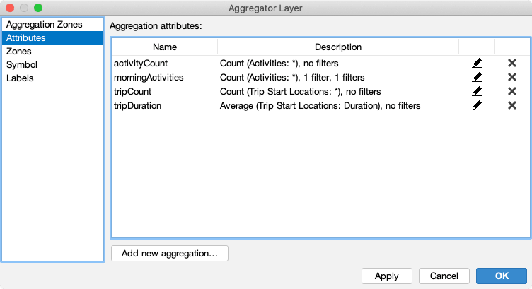
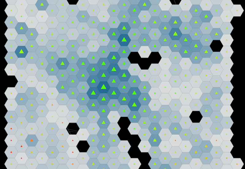
And to make use of the multiple aggregations, the Aggregation Layer now supports not only visualizing the actual zones, but also supports visualizing the aggregations by symbols that can be styled with color, size, transparency, etc.
GIS interoperability
Via 20.2 now supports GeoJSON in various places: First, GeoJSON data can be loaded and visualized with the Shapes Layer, similar how it was already possible with ESRI Shape files before. Second, GeoJSON is now available as data format when exporting spatial data. This includes exporting networks, exporting XY data, transit data, or aggregator zones.
Via actually supports two different flavors of GeoJSON: for one, it can load GeoJSON-files containing a
feature collection (typically ending on *.geojson), and so-called newline-delimited GeoJSON-files, which contain
multiple separate GeoJSON objects, each encoded on a single line, and separated by newline characters (typically
ending on *.geojsonl, also referred to as GeoJson Lines).
In addition to GeoJSON, the new Via version also supports loading data from GeoPackage databases (*.gpkg),
which are supported by more and more GIS applications.
Additional changes
In addition to the major improvements listed above, the following smaller changes and bugfixes are also part of Via 20.2:
- Improved scripting support for Network layer, including LinkVolumes and IntersectionFlows analysis.
- Add support for additional emission types from HBEFA 4.1 to the Emissions plugin.
- Provide Trips and Legs to Aggregation analysis, not only Legs.
- Simplified selection of custom coordinate reference systems.
- Fix loading and displaying facilities’ activities options.
- Label backgrounds did not correctly scale with font size in some cases.
The Via manual available online was adapted and extended extensively as well, covering all the new functionality and improved the documentation of existing functionality.
Download the latest version
Go to the Download section to get the newest version of Via!